![Earl Crossing Katahdin Stream](https://www.maineiat.org/wp-content/uploads/2024/02/Earl-Raymond-300x300.jpg)
The International Appalachian Trail lost a great friend, advocate, volunteer, and leader on Saturday, February 3, 2024.
Earl Raymond lived a long and full life, and he died just a couple of months shy of his 95th birthday.
Walter Andersen introduced Earl to the IAT shortly after our 10th anniversary celebration in Riley Brook, New Brunswick in June 2004. Roxanne Quimby had begun to acquire the land east of Baxter State Park that would become Katahdin Woods and Waters National Monument, and we hoped to be able to find a route for the trail out of Baxter and northward to the border. Old woods roads could be followed, but how were we going to get up and over Deasey Mountain? Walter had an answer, “I think Earl Raymond can help us.”
![Earl 10](https://www.maineiat.org/wp-content/uploads/2024/02/Earl-10-150x150.jpg)
![On June 6, 2009, Earl helped to celebrate the visit of a delegation of Maine and Newfoundland IAT members, here with Earl are Don Hudson, Eric Horshak, Torrey Sylvester, our hosts from the British Geological Survey of Scotland, Graham Leslie and Hugh Barron, Dick Anderson, and Walter Anderson.](https://www.maineiat.org/wp-content/uploads/2024/02/Earl-9-150x150.jpg)
![Earl was a constant companion and trail crew member for years, here on the porch of 'The Aces' at Bowlin Camps, with Don Hudson, Kirk St. Peter, Earl, Dave Rand, Cheryl St. Peter, Bill Duffy (and Tripp!).](https://www.maineiat.org/wp-content/uploads/2024/02/Earl-8-150x150.jpg)
![At the Ulster American Folk Park, following the ceremony at Kelly's Bridge, Earl and Don sport County Fermanagh ties received as gifts from the Park's staff.](https://www.maineiat.org/wp-content/uploads/2024/02/Earl-7-150x150.jpg)
![Earl, Rebecca, Inga, Ed Friedman, Inga's partner Mark, and Phine celebrate the sun halfway through the hike to Donegal Town.](https://www.maineiat.org/wp-content/uploads/2024/02/Earl-6-150x150.jpg)
![In October 2016, Earl and Maureen are in the midst of a scrum of U.S., Canadian, and Irish delegates at Kelly's Bridge between County Donegal in the Republic of Ireland (foreground) and County Tyrone in Northern Ireland (background), listening to the well-wishes of the mayors of Donegal Town, Ireland and Strabane, Northern Ireland upon the completion of the IAT on the island of Ireland.](https://www.maineiat.org/wp-content/uploads/2024/02/Earl-4-150x150.jpg)
![On June 3, 2016, Earl, on the left, explains how a Fire Watchman would use the map table and alidade to accurately locate any potential fire within the 360˚ view of the Fire Lookout on Deasey Mountain. Photo courtesy of Chunzeng Wang.](https://www.maineiat.org/wp-content/uploads/2024/02/Earl-2-150x150.jpg)
![On June 5, 2009, Earl reached the summit of the tallest mountain in the United Kingdom, Ben Nevis, outside Fort William, Scotland. L-R. Newfoundland's Kevin Noseworthy and his partner, British Geological Survey of Scotland's Graham Leslie, and Hugh Barron, Earl, Eric Horshak, famous Scottish outdoorsman Chris Townsend, and Newfoundland's Annie Wentzell and Paul Wylezol.](https://www.maineiat.org/wp-content/uploads/2024/02/Earl-10-1-150x150.jpg)
Walter and Earl had worked together during the search for a low-level nuclear waste repository in Maine during the 1980s. Earl was the chief operating officer of the Sewall Company, and among other skills was a renowned surveyor. A graduate of the University of Maine at Orono, Earl went on to earn a Master’s degree at the Yale School of Forestry––now the Yale School of the Environment. After a short stint with the National Park Service and the U.S. Forest Service, Earl joined the Sewall Company in Old Town, Maine in the late 1950s.
Earl’s fingerprints are on a number of significant corners of Maine, not the least of which is the Allagash Wilderness Waterway. The Waterway was established by the Maine Legislature in 1966, following a long negotiation with large landowners, it fell to Earl to organize the surveying and boundary marking of the state-owned Restricted Zone. When those around the negotiation table asked how long it would take to do the job, the Sewall Company representative said three summer seasons. No go! The job had to be done in 6 months. Earl took on the challenge, and his first decision was to hire Penobscot citizen and guide Joseph Sapiel to lead the operation––set up the camps, cook the meals, and move the teams of surveyors to their work. Guide Sapiel agreed to take on the work, but only if Earl would also hire his grandson as second in command––’Cookee’, in the parlance. With Joseph’s Sapiel’s and his grandson’s help, Earl’s crews completed surveying and marking the Waterway boundaries in the 6-month window they were given.
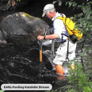
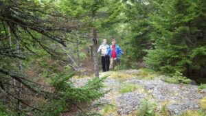
Earl joined the IAT board of directors the moment Walter put the question to him, and shortly thereafter he proposed a route across Wassataquoik Stream, along the Keep Path—and old route to Katahdin from the east, and up to the summit of Deasey.
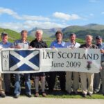
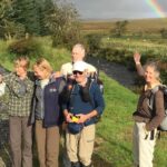
A few years later, in June 2009, Earl joined a delegation of Maine and Newfoundland IAT leaders to Scotland. Some of us climbed Ben Nevis, the tallest mountain in the UK. At 80-years old, Earl stuck with me as I limped down the mountain on my recently surgically repaired ankle. We crossed a mountain stream half way down and Earl urged me to “ice” my foot and ankle. Earl looked after us!
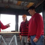
In 2015, Earl decided that the Fire Lookout on Deasey Mountain needed to have the watchman’s fire spotting table restored. He found a copy of the original 360˚ map of the land surrounding Deasey at the Sewall Company and he fashioned a new alidade––surveyor’s spotting device––to be installed on the circular table top. The new tabletop and alidade were installed by Earl and others on June 3, 2016.
![](https://www.maineiat.org/wp-content/uploads/2024/02/Earl-and-Susan-300x169.jpg)
Phine Ewing and I traveled to Donegal in the Republic of Ireland and Northern Ireland in October 2016, along with friends Rebecca Marvil and Brian Smyth, and fellow Maine IATers, Earl, his partner Maureen, and Ed Friedman. Our motley crew spent a week walking from the famous sea cliffs at Slieve League to Donegal Town, before attending the Annual General Meeting of the IAT in Strabane, Northern Ireland. Earl was 87! Earl and Maureen were right in the middle of things, notably as we gathered at Kelly’s Bridge between County Donegal, Republic of Ireland and County Tyrone, Northern Ireland. It was the first such project between these countries since the Good Friday accords.
Earl was a stalwart and tireless companion and we’ll miss him. Please consider making a donation in Earl’s memory and honor to the Maine Chapter of the International Appalachian Trail.