 Leaders: Joe Norman and Julia Daly
Time: 8 AM, parking at the end of the Orin Falls Road in KWWNM; return between 4-6 PM.
Difficulty and length: 10 miles (16 km) round trip; moderate to steep climbs, large stream crossing, a beaver dam crossing, and exposed walking near summit. Much of this walk crosses easy, rolling terrain. However, the last mile to the summit of Deasey is quite steep.
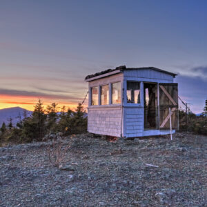
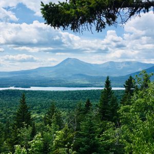
Description: This trip is an out-and-back that begins with fording Wassataquoik Stream, then follows a mix of new trails and historic logging roads through hardwood and softwood forests to the site of the former fire warden’s cabin. From there, the trail climbs steeply to the summit of Deasey Mtn where hikers may be rewarded with a stunning view of the Katahdin (weather-permitting). The summit also hosts the fire cab with a refurbished map and alidade. We will return by the same trail, re-crossing the Wassataquoik near the end of the hike. We will have several group check-ins en route to tell the stories of the history of the area along the way.
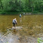
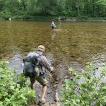 Note on the Wassataquoik Ford: The water level should be knee-high or lower, depending on recent rainfall. The footing is on rounded, unstable cobbles which are fairly uncomfortable on bare feet. We recommend you bring a pair of light-weight water shoes or old sneakers to cross the stream. Hiking poles are also highly recommended.
 Leaders: Don Hudson and Chunzeng Wang
Time: 9 AM from the Shin Pond Village parking lot. We will return to Shin Pond Village no later than 4 PM.
Difficulty: After a 7.5 mile drive from Shin Pond Village to the trailhead, there is a 1 mile (1.6 km) relatively steep hike to the top of Sugarloaf.
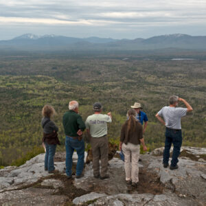
Description: “Little” Sugarloaf is due west of Shin Pond. After reaching the trail head at the end of the Grondin Road (heading west off Rt. 159 approximately 4.5 miles south of Shin Pond), the trail heads through a northern Appalachian hardwood forest before reaching the evergreen spruce and fir just below the summit. The upper half of the trail is steep, and we’ll take a break along the way to visit the fossil location discovered by USGS and Smithsonian geologist Bob Neuman in the 1950s. Dr. Neuman determined that the fossil animals preserved in the rock at this location are identical to fossils found in Wales and Ireland, and his determination was one of the important discoveries that proved the theory of continental drift. The eastern half of Baxter State Park and the entire Katahdin Woods & Waters National Monument are visible from the summit. We’ll retrace our steps following lunch, and carpool back to Shin Pond Village by mid-afternoon.
Leaders: Eric & Elaine Hendrickson
Time: Meet at 9:30 at the Bowlin Camps Road sign on Rt. 159, about 10 miles west from Shin Pond Village. A $10 parking fee is charged at the camps, so we will carpool for the drive in to minimize costs. We will return to Bowlin Camps by 3:00 PM.
Difficulty: A 7-mile (11.2 km) round trip over gently rolling terrain with two stream crossings that are typically easy rock-hops.
Description: The hike is along a remote section of the IAT within Katahdin Woods and Waters National Monument to the location of the historic Little Spring Brook Fish Hatchery. After crossing the East Branch of the Penobscot River on a suspension bridge the trail travels along the west side of the river through a mixed forest. The history of the hatchery and the old Telos Tote road will be described along the way.
 Leaders: Nancy Hathaway, Earl Raymond, and Josh Bowe
Time: 11 AM from Sandbank Campsite in KWWNM, carpool to the Barnard Trail Head parking lot.
Difficulty: The trail is moderate with a reasonable climb to the summit of the mountain.
Description: The trail is 4.5 miles (7.2 km) round trip with the first section on an old logging road and then into the woods and up the mountain (1,621 ft.). At the top on a clear day there are great views looking toward Katahdin Lake and Katahdin.